By Natalie Willis, Reporter, Valley Ag Voice
To the fertile country and part of the faded country of the San Joaquin Valley, the last flows were freed reluctantly, and they did not quiet the fields now turning to dust. Rows of almonds and pistachios stretched long over the valley floor, and the empty field beside them lay open to the wind. Uncertainty came, and went, and in time it began to stay. The soil broke into fine powder, a thin, restless skin, and as the sky grew pale, so the land grew pale, gold in the orchards, gray where nothing grew at all.
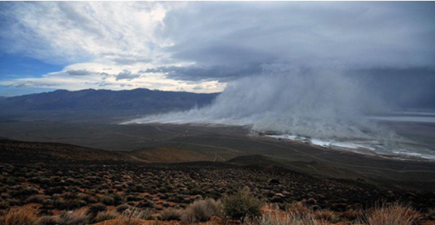
In California agriculture, such scenes are no longer confined to pages of John Steinbeck’s novels or the memories of the Dust Bowl generation. They are a reality for many growers under the Sustainable Groundwater Management Act, which is driving one of the largest land use transitions in state history.
In 2024 alone, nearly 17,000 acres of farmland were removed from production, according to the Water Association of Kern County. According to a new University of California report, with contributions from seven campuses, roughly 77% of fallowed land in California is associated with about 88% of major human-caused dust events.
The report, “Beyond the Haze: A UC Dust Report on the Causes, Impacts, and Future of Dust Storms in California,” found that while the future of dust in California is still uncertain, findings suggest dust storms will likely increase. According to UC Merced Professor and study co-author Adeyemi Adebiyi, an underlying cause is policies like SGMA which require farmers to limit the amount of water used for operations.
“One consequence is that Central Valley farmers may have to fallow or abandon about 1 million acres of land to comply with the law. That is a lot of land that can become exposed to wind erosion, resulting in another dust source,” Adebiyi said in a press release.
The impacts of dust on human health are wide-reaching, including respiratory and cardiovascular diseases, allergic conditions, fungal infections, and even traffic accident injuries, according to the UC report.
Consequently, new data from the California Department of Public Health shows that Valley Fever cases have increased across the state, most notably in Kern County. In the first three months of 2025, over 3,000 cases were reported in the state — almost double the 10-year average.
In 2024, cases and deaths from Valley Fever reached the highest in recorded history, accounting for 3,990 cases and 49 deaths in Kern County. This uptick, according to county officials, is likely linked to the cycle between drought years and wet years.
“Data shows that in the two years following a drought, cases of Valley Fever rise. With the second year being the highest,” Paul Rzucidlo, Assistant Division Director of Kern County Health Services, told KBAK. “After the drought beginning in 2020, heavy rains in 2022 were followed by rising case counts in 2023 and 2024.”
The UC report affirmed that incidence of Valley Fever is on the rise in California due to increased dust exposure, and more regions are expected to become endemic. Changes in land use will continue to exacerbate the issue.
“The San Joaquin Valley is also facing the possibility of fallowing approximately 900,000 acres (17.7% of the San Joaquin Valley’s agricultural fields) of cropland by 2040 as a result of shifting climatic conditions and the Sustainable Groundwater Management Act, which will likely increase the amount of dust emitted from agricultural fields,” the report stated. “These changes in land use and land cover have resulted in the creation of novel dust sources in California that previously were less susceptible to aeolian processes.”
THE LONG VIEW ON LAND USE
History shows that changing the way land is used, without an adequate plan for what comes next, can bring unintended consequences. After World War II, for instance, the expansion in the state’s population and development led to increased urbanization and the conversion of agricultural land to other uses.
Additionally, California farms began consolidating into larger operations as a result of rapid mechanization, leading to a 10% decrease in farm labor as well as a decline in the amount of farmland, according to the Giannini Foundation of Agricultural Economics’ report, “The Evolution of California Agriculture 1850-2000.”
“The use of capital services—including physical inputs such as automobiles, tractors, trucks, and combines, as well as biological inputs such as dairy cows, ewes, and breeder pigs—grew by over 75% from 1949 to 1991,” the report stated. “However, quality-adjusted land and labor use in agriculture declined. Land use fell by 8%, while labor use decreased by 10%.”
As a result of the transition in land use, the Williamson Act of 1965 was introduced to encourage farmers to maintain their land in agricultural production by providing tax incentives.
While the Act has slowed the loss of productive land, the number of farms in the state continues to decrease, driven toward consolidation with larger operations. According to the 2022 Census of Agriculture, California farms have decreased by 10.5% between 2017 and 2022, with the sharpest declines occurring among smaller farms.
Alongside large-scale shifts in agricultural land-use due to rapid urbanization and mechanization, a wave of habitat and water quality legislation in the 1970s through the 1990s reshaped farming near rivers, wetlands, and endangered species habitats.
The American Bar Association classifies the 1970s federal environmental laws as “dramatic, sweeping, and uncompromising.”
Most notably, this time period saw the launch of the National Environmental Policy Act, the Clean Air Act, and the creation of the Environmental Protection Agency. Over the decade, Congress passed nearly two dozen sweeping laws, including the Clean Water Act and Endangered Species Act.
“Congress continued passing far-reaching laws, and the courts—including the Supreme Court—broadly interpreted them both in terms of their jurisdictional reach and their regulatory rigor,” the ABA stated.
Putting it mildly and succinctly, these regulations have greatly impacted California’s agricultural landscape. The Endangered Species Act in particular has limited the productive use of farmers’ and ranchers’ most principal asset — land.
According to the American Farm Bureau Federation, ESA restrictions disproportionately affect farmers and ranchers because they own most of the land where plant and animal species are found.
In an issue overview, the AFBF explained that farmland is open, unpaved, and relatively underdeveloped, which provides potential habitat for listed plants and animals. In a 2018 report, Zippy Duvall, president of the AFBF, explained that as the land around farms becomes more urbanized, farmland is viewed as a “last refuge” for wildlife.
“I recall meeting with a cranberry farmer in Massachusetts who could not farm sections of his own land, in order to leave a designated habitat for the endangered box turtle,” Duvall said. “Meanwhile, the area surrounding his land has been developed with no such restrictions. This same farmer has not seen a box turtle on his land in 20 years.”
There have also been historical cases of agricultural land conversions causing air quality issues across the U.S., such as the Dust Bowl that afflicted the Great Plains in the 1930s, according to a July 2022 report from the Public Policy Institute of California — “Land Transitions and Dust in the Central Valley.”
The San Joaquin’s soil and climate lends itself to similar conditions.
“While the valley saw important reductions in particulate concentrations throughout the early 2000s, these have been partially reversed recently (in part by increased wildfire activity), and looming transitions of land out of regular irrigated production present additional risks,” the PPIC report explained.
SAME DUST, NEW BOWL
As seen above, agricultural policies, whether intended or not, can create ripple effects that impact economies, communities, and the environment, according to a 2006 U.S. Department of Agriculture’s Economic Research Service study, “Agricultural Policy Affects Land Use and the Environment.”
It should be noted that while the referenced USDA study was published nearly two decades ago, and nine years prior to SGMA’s passage, such research offers a snapshot in time and findings that often gain clarity in the years that follow.
The report observed that agricultural and conservation policies can directly or indirectly influence farmers’ land-use decisions, particularly for less economically productive land, which also tends to be more environmentally sensitive than average cropland. This is evident today in the acres now being removed from production under SGMA’s water restrictions.
According to the more recent UC Dust report, changes in government policies can influence agricultural land-use management practices with direct consequences for wind erosion. While it is well-understood that the San Joaquin Valley’s groundwater basins must find balance in the next two decades, the transition of farmland out of irrigated agriculture was likely not managed with enough foresight for the consequences.
Two agencies oversee the implementation of SGMA — the California Department of Water Resources and the State Water Resources Control Board. The initial phases of implementation were led by DWR, which reviewed and assessed Groundwater Sustainability Plans for compliance.
The State Water Board is tasked with enforcing the law and intervening when local entities fail to comply, specifically in the event that DWR determines the GSPs are inadequate to achieve sustainability in a given basin.
However, as the non-partisan Legislative Analyst’s Office questioned in a Feb. 21, 2024, report to the Assembly Committee on Water, Parks, and Wildlife — how are DWR and the State Water Board considering the increase in toxic dust from farmland that is taken out of production?
So far, the unintended consequence of dust erosion has not been explicitly covered under SGMA guidelines.
Andrew Ayres, research fellow at the PPIC Water Policy Center and an assistant professor of economics at the University of Nevada, Reno, explained that interagency coordination is critical to control dust from fallowed land.
“Up until now, a lot of the land transitions that are coming about as a result of the SGMA have been part of larger coordinated efforts to transition large portions of land, and in those sorts of settings, it can be a little bit easier sometimes to plan for dust mitigation,” Ayres said. “Moving forward, we’re probably going to see some continuation of those types of large, coordinated projects, but also, a little bit more decentralized uncoordinated fallowing as well. So, in those cases, additional guidance both from the state level and from the regional level, especially with respect to the air quality, [the] Air Pollution Control District, is going to be very important.”
State efforts thus far, he explained, have provided valuable tools to study the issue such as data from the California Air Resources Board which has updated modeling in relation to emission inventories.
While dust can be mitigated through strategies such as cover cropping, farmers often lack incentives to adopt them, making sustained local, state, and federal funding essential for proactive dust management.
Ayres explained that several Groundwater Sustainability Agencies have implemented or plan to implement groundwater accounting systems that allocate each landowner a set amount of groundwater, with usage debited when the land is irrigated.
“What are the rules around maintaining vegetative cover? Like ‘Oh, you maintained a cover crop, but that meant that those crops used water that otherwise would have gone into the groundwater,’” Ayres said. “That’s a disincentive to managing dust.”
As a result, he explained that some GSAs may need to rethink the way cover crops are viewed within the groundwater accounting systems.
For example, two GSAs in the Tule Subbasin implemented volumetric groundwater accounting and allocation systems, allowing landowners who use cover crops to avoid charges for the crops’ evaporative water use.
At the federal level, the USDA Natural Resources Conservation Service would be a key player in offering cost-effective dust management guidance and funding for practices like cover cropping. According to Ayres, NRCS has programs like the Conservation Reserve Program which provides an annual rental payment to farmers who remove “environmentally sensitive” land from production and plant species that help improve environmental health.
“They also have, under the Environmental Quality Incentives Program, a specific focal area on cover cropping that up until recently has not really been widely used in California, but this might be one of those areas where you see some growth,” Ayres said.
In the 2022 PPIC report, Ayres and his co-authors emphasized that with every successful dust management effort in California and the American West, a dedicated funding source was paramount.
“And that funding actually, you know, we focus on state and federal right now…that funding can come from regional bodies,” Ayres said. “GSAs, counties, and the San Joaquin Air Pollution Control District might also have a role to play there.”
Looking ahead, Ayres identified four governance priorities: identifying dust-risk priority areas, expanding awareness of vegetative cover options, aligning groundwater accounting rules with dust mitigation goals, and clarifying how the San Joaquin Valley Air Pollution Control District will handle fallowing under its regulations.
While significant land has yet to come out of production, Ayres sees an opportunity to coordinate the many considerations involved in land transitions, including dust mitigation.
“We’ve still got time,” Ayres said. “Getting dust right means finding sustainable funding sources to make on-farm mitigation measures sustainable in the long run, and also identifying priority mitigation areas, like ‘Where do we really want to make sure that this doesn’t go wrong?’”
REPORTER’S REFERENCES
Several studies and reports were referenced; for further details, please see the references below.
- Steinbeck, John. The Grapes of Wrath. Viking Press, 1939.
Inspiration from the first paragraph of “The Grapes of Wrath” was utilized by the reporter to form a connection to the San Joaquin Valley.
- (2025). Beyond The Haze: A UC Dust Report on the Causes, Impacts, and Future of Dust Storms in California.
- (2017). Giannini Foundation of Agricultural Economics’ report, “The Evolution of California Agriculture 1850-2000.”
- (2022). Public Policy Institute of California, “Land Transitions and Dust in the Central Valley.”
- (2006). U.S. Department of Agriculture’s Economic Research Service study, “Agricultural Policy Affects Land Use and the Environment.”